Difference between revisions of "Advisory Flags (eng)"
| (2 intermediate revisions by the same user not shown) | |||
| Line 21: | Line 21: | ||
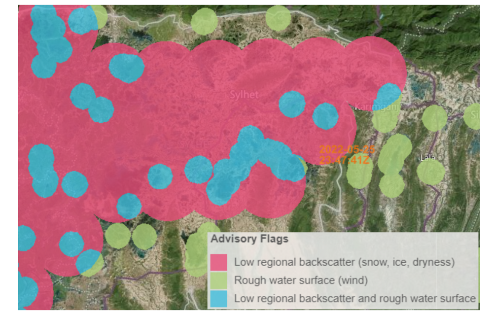
For each incoming Sentinel-1 scene that is input to the flood mapping algorithm, the advisory flag information will be generated during NRT runtime. After generating the Sentinel-1 observed water extent layer, the preprocessed 20m Sentinel-1 sig0 array will be analyzed and compared with the ''Calm Water Body'' signature database to obtain pixels holding ''Rough Water Surface''. <br> | For each incoming Sentinel-1 scene that is input to the flood mapping algorithm, the advisory flag information will be generated during NRT runtime. After generating the Sentinel-1 observed water extent layer, the preprocessed 20m Sentinel-1 sig0 array will be analyzed and compared with the ''Calm Water Body'' signature database to obtain pixels holding ''Rough Water Surface''. <br> | ||
After the thresholding and spatial buffering, the obtained pixelmap that indicats regions that are potentially affected by wind is stored intermediately. <br> | After the thresholding and spatial buffering, the obtained pixelmap that indicats regions that are potentially affected by wind is stored intermediately. <br> | ||
| − | As next step, the 20m-oversampled sig40 data from the corresponding (i.e. temporally matched) 25km ASCAT observation dataset is compared to the local ASCAT sig40 20th percentile value, which is pre-computed and accessed from the data cube. <br> | + | As next step, the 20m-oversampled sig40 data from the corresponding (i.e. temporally matched) 25km [[ASCAT Wind(eng) |ASCAT]] observation dataset is compared to the local [[ASCAT Wind(eng) |ASCAT]] sig40 20th percentile value, which is pre-computed and accessed from the data cube. <br> |
All pixels with detected Low Regional Backscatter are forwarded to the intermediate storage and the final '''Advisory Flag''' pixel map for the Sentinel-1 scene extent is computed. The Advisory Flag layer values are described below. | All pixels with detected Low Regional Backscatter are forwarded to the intermediate storage and the final '''Advisory Flag''' pixel map for the Sentinel-1 scene extent is computed. The Advisory Flag layer values are described below. | ||
|- | |- | ||
|Screenshot | |Screenshot | ||
| − | |[[File:GFMADFL. | + | |[[File:GFMADFL.png|1000px|thumb|centre|]] |
|- | |- | ||
|style="background-color: grey;"| Properties | |style="background-color: grey;"| Properties | ||
| Line 31: | Line 31: | ||
|- | |- | ||
|Available variables | |Available variables | ||
| − | | | + | |rough water surface |
|- | |- | ||
|Available accumulations | |Available accumulations | ||
Latest revision as of 09:14, 4 August 2022
| Layer name | Advisory Flag (GFM) |
| Tag | Flood |
| Folder | Eo Satellite |
| Source | GFM Products Wiki |
| Description | The Advisory Flag layer indicates pixels that potentially suffer from decreased contrast between water and non-water surfaces due to meteorological factors as wet snow, frost and dry soil or wind-roughened water. Pixels marked by the Advisory Flag are not excluded by the Exclusion Mask, but users are advised caution when using the observed water and flood extents over flagged areas. |
| Screenshot | |
| Properties | |
| Available variables | rough water surface |
| Available accumulations | |
| Available interpolation algorithms | |
| Available filters | |
| Spatial aggregations |
