Difference between revisions of "ALGORITHM3"
(→References) |
|||
| (5 intermediate revisions by the same user not shown) | |||
| Line 8: | Line 8: | ||
The maximum posterior probability is used to classify the pixel based on [https://en.wikipedia.org/wiki/Decision_theory Bayes Decision Rule], where the uncertainty of the class assignment is given by the minimum posterior probability of the other class. With this approach, each pixel is assigned membership in a certain class, along with an uncertainty value ranging between ''0'' and ''1''.<br> | The maximum posterior probability is used to classify the pixel based on [https://en.wikipedia.org/wiki/Decision_theory Bayes Decision Rule], where the uncertainty of the class assignment is given by the minimum posterior probability of the other class. With this approach, each pixel is assigned membership in a certain class, along with an uncertainty value ranging between ''0'' and ''1''.<br> | ||
| − | The uncertainty is minimized as with improved separability between the two backscatter signature distributions and is higher where the distributions overlap ( | + | The uncertainty is minimized as with improved separability between the two backscatter signature distributions and is higher where the distributions overlap (see figure below). |
[[File:alg3.jpg|centre|800px|border]] | [[File:alg3.jpg|centre|800px|border]] | ||
''Water PDF, non-water PDF, water posterior probability and non-water posterior probability with equal priors (0.5) for a flooded pixel. The backscatter measurement equals to -15dB. Thus, the pixel is classified as water, because the posterior probability of water is larger than non-water. The uncertainty is then the posterior probability of non-water, reflecting the overlap of both PDFs.'' | ''Water PDF, non-water PDF, water posterior probability and non-water posterior probability with equal priors (0.5) for a flooded pixel. The backscatter measurement equals to -15dB. Thus, the pixel is classified as water, because the posterior probability of water is larger than non-water. The uncertainty is then the posterior probability of non-water, reflecting the overlap of both PDFs.'' | ||
| − | Consequently, pixels located along flood boundaries, where class assignment is generally more challenging, are associated with higher degrees of uncertainty. Finally, to convert the uncertainty values to percentages, the uncertainty values are linearly scaled to fall within the range of [0, 100]. | + | Consequently, pixels located along flood boundaries, where class assignment is generally more challenging, are associated with higher degrees of uncertainty. Finally, to convert the uncertainty values to percentages, the uncertainty values are linearly scaled to fall within the range of ''[0, 100]''. |
====<u>''Workflow of the algorithm''</u>==== | ====<u>''Workflow of the algorithm''</u>==== | ||
| Line 19: | Line 19: | ||
| + | ====<u>''In a nutshell''</u>==== | ||
| + | '''Algorithm''' 3 fully exploits the '''entire Sentinel-1 signal history''' within the data cube, realized by a set of '''a-priori computed statistical parameters layers''' that provide a highly accurate '''characterization of Earth’s land surface at pixel level''', as well as of the '''incidence angle dependency''' in respect to the Sentinel-1 mission. With those parameters as input, and with the '''mathematical legacy of Bayes''', the water delineation procedure can be designed '''computationally relatively slim''' and is hence '''most suitable for global operations in near-real time'''. | ||
| − | '''For further details the Reader is referred to the dedicated section of the Product Description Document: https://www.gfm_pdd.org/ | + | |
| + | '''For further details the Reader is referred to the dedicated section of the Product Description Document: https://www.gfm_pdd.org/Algorithm3''' | ||
====<u>''References''</u>==== | ====<u>''References''</u>==== | ||
| − | <sup>[1]</sup> | + | <sup>[1]</sup> Bauer-Marschallinger, B., Cao, S., Wagner, W., Navacchi, C., Tupas, M.E., Roth, F., Melzer, T., Freeman, V. (in preparation). Satellite-based Flood Mapping through Bayesian Inference from Sentinel-1 SAR Datacube. Remote Sensing. |
| − | <sup>[2]</sup> | + | <sup>[2]</sup> <span style=background:yellow>MISSING</span> |
---- | ---- | ||
[[GFMS | [Home]]] - [[ALGORITHMS | [Algorithms]]] | [[GFMS | [Home]]] - [[ALGORITHMS | [Algorithms]]] | ||
Latest revision as of 11:34, 23 March 2021
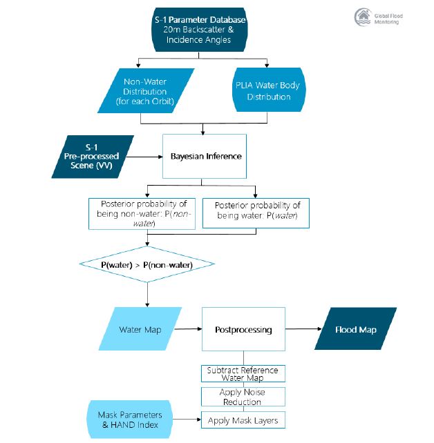
TU Wien’s S-1 flood mapping algorithm exploits the time series of historical backscatter measurements to generate model parameters for permanent water bodies and for each individual location on land.
More specifically, the model parameter database comprises of the backscatter distribution of each land pixel under unflooded conditions, as well as the backscatter distribution of permanent water bodies at various incidence angles. In order to classify a pixel of incoming pre-processed Sentinel-1 scene as flooded or non-flooded, the posterior probability of the actual backscatter value belonging to each class is computed.
The maximum posterior probability is used to classify the pixel based on Bayes Decision Rule, where the uncertainty of the class assignment is given by the minimum posterior probability of the other class. With this approach, each pixel is assigned membership in a certain class, along with an uncertainty value ranging between 0 and 1.
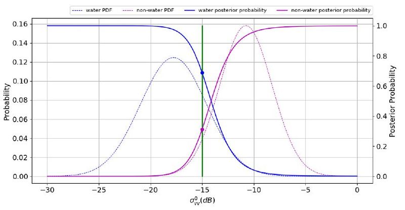
The uncertainty is minimized as with improved separability between the two backscatter signature distributions and is higher where the distributions overlap (see figure below).
Water PDF, non-water PDF, water posterior probability and non-water posterior probability with equal priors (0.5) for a flooded pixel. The backscatter measurement equals to -15dB. Thus, the pixel is classified as water, because the posterior probability of water is larger than non-water. The uncertainty is then the posterior probability of non-water, reflecting the overlap of both PDFs.
Consequently, pixels located along flood boundaries, where class assignment is generally more challenging, are associated with higher degrees of uncertainty. Finally, to convert the uncertainty values to percentages, the uncertainty values are linearly scaled to fall within the range of [0, 100].
Workflow of the algorithm
In a nutshell
Algorithm 3 fully exploits the entire Sentinel-1 signal history within the data cube, realized by a set of a-priori computed statistical parameters layers that provide a highly accurate characterization of Earth’s land surface at pixel level, as well as of the incidence angle dependency in respect to the Sentinel-1 mission. With those parameters as input, and with the mathematical legacy of Bayes, the water delineation procedure can be designed computationally relatively slim and is hence most suitable for global operations in near-real time.
For further details the Reader is referred to the dedicated section of the Product Description Document: https://www.gfm_pdd.org/Algorithm3
References
[1] Bauer-Marschallinger, B., Cao, S., Wagner, W., Navacchi, C., Tupas, M.E., Roth, F., Melzer, T., Freeman, V. (in preparation). Satellite-based Flood Mapping through Bayesian Inference from Sentinel-1 SAR Datacube. Remote Sensing.
[2] MISSING


