Difference between revisions of "GSMaP(eng)"
From MyDewetra World
(Created page with " [Home] - [Observations] <br/> {| class="wikitable" |- |style="background-color: orange;" |Layer name |style="background-color: orange;"|GS...") |
|||
| (One intermediate revision by the same user not shown) | |||
| Line 17: | Line 17: | ||
|- | |- | ||
|Description | |Description | ||
| − | |'The GSMaP Project was sponsored by JST-CREST and is promoted by the JAXA Precipitation Measuring Mission (PMM) Science Team, and the GSMaP products were distributed by the Earth Observation Research Center, Japan Aerospace Exploration Agency. Global Satellite Mapping of Precipitation (GSMaP) provides a global hourly rain rate with a 0.1 x 0.1 degree resolution. GSMaP is a product of the Global Precipitation Measurement (GPM) mission, which provides global precipitation observations at three hour intervals. Values are estimated using multi-band passive microwave and infrared radiometers from the GPM Core Observatory satellite and with the assistance of a constellation of other satellites. GPM's precipitation rate retrieval algorithm is based on a radiative transfer model. The gauge-adjusted rate is calculated based on the optimization of the 24h accumulation of GSMaP hourly rain rate to daily precipitation by NOAA/CPC gauge measurement. This dataset is processed by GSMaP algorithm version 6 (product version 3). | + | |'The GSMaP Project was sponsored by JST-CREST and is promoted by the JAXA Precipitation Measuring Mission (PMM) Science Team, and the GSMaP products were distributed by the Earth Observation Research Center, Japan Aerospace Exploration Agency. Global Satellite Mapping of Precipitation (GSMaP) provides a global hourly rain rate with a 0.1 x 0.1 degree resolution. GSMaP is a product of the Global Precipitation Measurement (GPM) mission, which provides global precipitation observations at three hour intervals. Values are estimated using multi-band passive microwave and infrared radiometers from the GPM Core Observatory satellite and with the assistance of a constellation of other satellites. GPM's precipitation rate retrieval algorithm is based on a radiative transfer model. The gauge-adjusted rate is calculated based on the optimization of the 24h accumulation of GSMaP hourly rain rate to daily precipitation by NOAA/CPC gauge measurement. This dataset is processed by GSMaP algorithm version 6 (product version 3).<br> |
| + | |||
| + | More info at: [https://sharaku.eorc.jaxa.jp/GSMaP/guide.html GSMaP documentation on line] | ||
| + | |||
|- | |- | ||
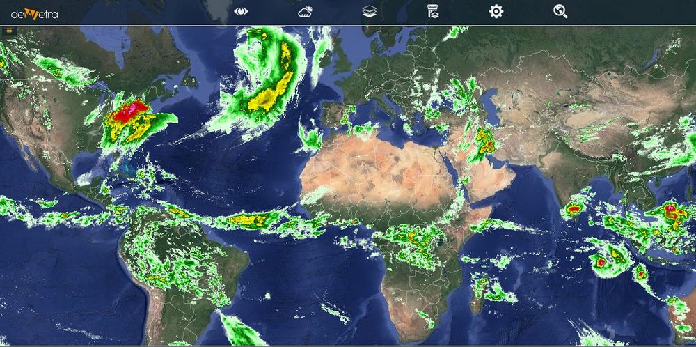
|Screenshot | |Screenshot | ||
Latest revision as of 15:32, 24 November 2020
| Layer name | GSMaP | |
| Tag | Rain | |
| Folder | ||
| Source | JAXA and NASA | |
| Description | 'The GSMaP Project was sponsored by JST-CREST and is promoted by the JAXA Precipitation Measuring Mission (PMM) Science Team, and the GSMaP products were distributed by the Earth Observation Research Center, Japan Aerospace Exploration Agency. Global Satellite Mapping of Precipitation (GSMaP) provides a global hourly rain rate with a 0.1 x 0.1 degree resolution. GSMaP is a product of the Global Precipitation Measurement (GPM) mission, which provides global precipitation observations at three hour intervals. Values are estimated using multi-band passive microwave and infrared radiometers from the GPM Core Observatory satellite and with the assistance of a constellation of other satellites. GPM's precipitation rate retrieval algorithm is based on a radiative transfer model. The gauge-adjusted rate is calculated based on the optimization of the 24h accumulation of GSMaP hourly rain rate to daily precipitation by NOAA/CPC gauge measurement. This dataset is processed by GSMaP algorithm version 6 (product version 3). More info at: GSMaP documentation on line | |
| Screenshot | ||
| Properties | ||
| Available variables | Rain depth | |
| Available accumulations | 1, 3, 6, 12 and 24 hours | |
| Available interpolation algorithms | ||
| Available filters | ||
| Spatial aggregations |

